(Aerial view of Santa Fe Opera)We first drove down Santa Fe’s “Opera Hill” heading north on U.S. Route 84 on our initial trip to New Mexico in 1992. Looking in wonder at the seemingly endless high desert landscape Marsha said to herself, “I’m home!” At the other end of town 382 years earlier a considerably less enthusiastic caravan of northbound Spanish settlers stood at the base of the basalt behemoth known as La Bajada and loudly moaned “are we there yet?”Both we and they were experiencing New Mexico for the first time. And, while the two of us liked to think that we were “exploring” someplace new, we had maps, pamphlets and locals to give us directions, recommendations and advice. El Colonos españoles were doing it for real, with nothing to guide them but their faith in God, their leader Juan de Oñate and the beaten path of the Indigenous Natives who preceded them on the trail that later became known as El Camino Real de Tierra Adentro.Last year Jim was talking to L, an epidemiologist from Los Alamos National Laboratories. (Apparently not top-secret work, so she didn’t have to kill him.**) During the conversation she mentioned that the Lab does much better retaining employees if they have lived previously in northern New Mexico. Her husband worked at LANL as part of Grad School. She herself was born and raised on “The Hill” – as her town of employment has been referred to since WWII’s Manhattan Project. (At the time the name “Los Alamos” was considered classified information.)“You either love it, or you hate it,” she went on. Most scientists who quit don’t do it because of the work, but because of landscape and physical environment. Thew same one that we so quickly fell in love with on our virgin visit. Of course we had our return flight booked two weeks out. So either way – not a problem for us. The colonists on the other hand only were given a one-way ticket when they set off on their 1,600 mile, multi-month hike to their future home. Going back was less of an option for them.The “road” on which the settlers traveled was an ancient trade route between the Southwestern and MesoAmerican Natives. Oñate received permission from the King of Spain to use it for his 1598 and subsequent colonization expeditions and established a settlement in the trail’s terminus San Gabriel – today known by its Native name of Ohkay Ohwingeh. In 1610 Don Pedro de Peralta, Oñate’s successor as Colonial Governor, moved the community back down the road 40 miles to the newly founded town of La Ciudad de Santa Fe de San Francisco (City of the Holy Faith of St. Francis, or Santa Fe for short.)To which the shortest, but not the easiest, way was La Bajada Hill – an ascension of 1,500 feet in 3/4 of a mile at an angle of 45°. (La Bajada is Spanish for "the descent.") Peralta was also the earliest documented Spanish user of the hill. As the caravans approached Santa Fe there were three choices: scaling La Bajada, following “the Santa Fe River through the yawning canyon of Las Bocas, [or] another, longer trek around La Bajada through the Galisteo Basin,” according to the National Park Service web site. Oñate opted for the third.

(La Bajada with Unidentified Aerial Phenomena – it is New Mexico after all.Or it could be watermarks if you believe the government.)In the 20th century there were two alternative principal ways for getting from Albuquerque (where our flight came in) to Santa Fe. Interstate 25 is the most direct and fastest. NM 14 (the Turquoise Trail} more scenic and pleasant. And it turns out that nowadays off of the Santa Fe end of Route 14 is an entryway (entrada) to our home in Rancho Viejo – a 23,000-acre (39 sq. ml.) parcel of land south of the city. The Turquoise Trail was not available to Oñate, et al. But we like to think that these early colonists might nonetheless have passed through what is now our neighborhood. To have that connection to such an historic roadway would be pretty cool.

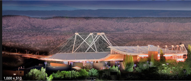
Documentation shows Oñate’s chosen route brought him to the Native American settlement that the Spanish called Pueblo San Marcos – a short distance from what is today the southern end of the Ranch Viejo property.A major reason for coming this way was the presence of the Galisteo Creek/River. During the 1800s Santa Fe residents and visitors such as soldiers of both the U.S. Cavalry and the Confederate Army would regularly water their horses, and themselves, at the perennial stream that flows from the eastern highlands down into the Rio Grande through Galisteo. Jim learned all this during a one-on-one meeting he was fortunate enough to have with Dr. Eric Blinman, Director of the state’s Office of Archaeological Studies (OAS.) Jim was researching the history of Rancho Viejo And Dr. Blinman pointed out that it is a “straight shot” from Galisteo Creek through Rancho Viejo to Santa Fe. Like a lawyer who got the answer he hoped for, Jim quickly changed the subject.And it was during an evening class at the OAS taught by the same Dr. Blinman where we both learned of the historic significance of La Bajada – although the following comes mostly from the USDA Forest Service website.Archaeological findings place humans activity at the top of La Bajada Mesa during the early Archaic Period (5500 BC-AD1), a time “when cultures were shifting from reliance on now-extinct mega fauna to smaller game and wild plant gathering. The area provided high quality basalt for stone-tools and a diversity of useful plant and animal species.“In the few centuries before European contact (AD1300-1600) the population increased dramatically … Archaeologists have identified and dated the remains of several residential sites, known as pueblos, at the base of La Bajada … and large agricultural areas on top of the mesa [such as] grid gardens and … cobble mulch fields. “While it may not seem like the top of the mesa would be a good place to try to grow crops, people from the pueblo below knew how to make the most of the little moisture they received by creating stone alignments that collected and channeled the rainwater. They also used stones to mulch or cover the dirt in which they planted, to minimize evaporation. It is possible that the people who walked across the plateau tending their fields followed a route similar to the historic trail and road alignments that later climbed the same hill.”Today the NPS cautions, “only the best prepared, and most adventurous, modern-day trekkers will want to take on the black basalt backcountry of La Bajada.” And yet, driven by “God, Gold and Glory,” multiple expeditions of conquistadors and colonos españoles did just that. As did those that came after them, modifying the pathway into todays’ trail, which historians believe has “been in use [in basically that configuration] for some 300 years. The switchbacks on the road were supposedly blazed by U.S. Army troops in the 1860's for cavalry passage. In the early 1900's, because of the gravity-fed gas tanks of the time, many vehicles were forced to use their most powerful gear – reverse – to climb backwards up the steeper switchbacks. In the 1920's, the top half of the climb was rerouted on a gentler alignment just to the east of the old route … In 1934, the Highway Department "moved" the road three miles to the east to the same route currently used by I-25 … The La Bajada [walking] Trail is about 15 miles long and takes approximately 4 hours or so to complete." (New Mexico 4-Wheelers)(Unclear if the vehicle is coming down or going up.)Juan de Oñate not only did not scale La Bajada. He also blew off Opera Hill – or whatever it was known as at the time. His journey north from Santa Fe north to his settlement at San Gabriel took him more than five miles to the west of the awe-inspiring panoramic view that continues to wow the two of us today. We are fortunate to be able say that the Royal Road MAY have passed near our backyard. Having it continue on to our favorite vista in the entire world would be asking way too much of history.American musician, conductor, arts administrator and Santa Fe Opera founder John O. Crosby learned of the property that would become Opera Hill in 1956, when it was a guest ranch catering to classical music luminaries of the day such as soprano Lily Pons and her husband conductor André Kostelanetz. At the time it was basically 76 acres of sparsely developed land following its previous lives as a pinto bean plantation, a mink ranch and a pig farm. Crosby signed a three year lease and the rest as they say is history.Was it the price and availability of the land? Probably. Was it the view? Most definitely. Each iteration of the auditorium – 1957, 1967 and 1998 – followed Crosby’s vision of of an open-air theatre that took advantage of Santa Fe’s “ideal climate, natural beauty, and [the] interest of the public in the great southwest.” The building faces west toward Jemez Mountains. To the east the Sangre de Cristos, the southernmost subrange of the Rockies. Panels behind the stage separate to revel a dramatic view of sky and mountains. Performances begin at sunset and, like our experience at a Renee Fleming concert in 2019, are sometimes accompanied by torrential thunderstorms that can drench parts of the audience and the performers.(Santa Fe Opera founder John Crosby.)But as impressive as it is, the Opera grounds do not provide the best view in town. That viewing point was already taken by 1956 – Route 84 in Santa Fe having settled into its current location in 15 years earlier. The vista itself was there long before either of these dates. It was there when the first MesoAmericans walked north from Mexico City to San Juan Pueblo. It was there in 1200 A.D, when the Tesuque Natives created their first Pueblo on part of the land that makes up this panorama. It was there in 1598 when Juan de Oñate went north to proclaim the Pueblo of San Juan as the first Spanish settlement in New Mexico. It was there when we first drove north out of Santa Fe in 1992. And it will be there should you decide to take that same ride down Opera Hill.1,900 of our words cannot adequately describe it. Nor can an IPhone video shot at 75 mph capture it. You have to see it in person to decide. You’ll either love it or you’ll hate it. You already know how we feel.(Getting to “The Hill” ca. 1945)


No comments:
Post a Comment